Extreme rainstorms and flash floods have become an increasingly common problem for New Yorkers in recent years.
Thunderstorms that hit New York City recently dumped nearly six inches of rain on some parts of Brooklyn and prompted a citywide flood advisory. Storms like this can easily overwhelm a sewer system built to withstand up to 1.75 inches of rain an hour.
As rising sea levels and a warming climate bring more extreme weather events to the city, its sewer systems will need major upgrades—but over $350 million in funding allocated for storm mitigation projects was pulled back by the Trump administration last year.
Amid this uncertainty, a Gowanus-based resilient landscaping company is helping local residents take flood mitigation efforts into their own hands.
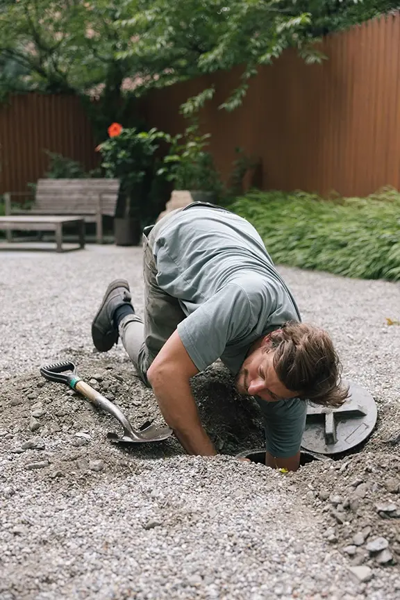
Since 2017, the company, Field Form, has completed more than 350 landscaping projects designed to manage flooding and other climate impacts, including over 100 stormwater mitigation projects. Many of their installations are simple dry wells, which capture and release stormwater runoff into surrounding soil. Samuel Robinson, co-founder of the company, estimates that these projects collectively divert about two million gallons of rainwater from the city’s combined sewer system each year.
Now, Field Form has launched a new tool that helps property owners, block associations, and neighborhoods understand and respond to flood risk in their immediate area. The pilot neighborhoods for the Flood Form program include the particularly flood-prone neighborhoods of Gowanus and North Park Slope.
“We created Flood Form to bridge the gap between property-level problems and the larger watershed and sewer infrastructure systems that shape them,” Field Form’s Robinson told us.
The company has always aimed to help clients understand where stormwater comes from and how to manage it, not just divert the waters.
This tool lets residents proactively explore flood exposure where they live, including the most likely sources (groundwater, coastal water, or sewage backup) and how much stormwater their property can absorb. It also provides features like weather forecasting, storm analysis and flood mitigation strategies. Property owners pay for site visits and more detailed strategy reports.
Flood Form started as a tool used by in-house to assess their clients’ properties, but Robinson and his business partner Line Kaasine soon realized the data they were compiling would be invaluable to the general public.
Flood Form uses 35 different layers of data, including stormwater maps, NYC Open Data, real-time flooding levels, insurance information on previous storm damage and weather interpretation—“basically any information that we can possibly gather that’s available,” said Robinson.
A lot of crucial flood data is currently siloed in city, state, and federal agency databases, he said.
“That data, brought together, could be the first and simplest way for people to get a better sense of where they stand and be aware of creating a more resilient home, and by proxy a more resilient block and a more resilient city,” he said.
While conventional flood analysis tools primarily rely on FEMA floodplain maps, Flood Form also provides data on neighborhoods outside of traditional flood zones.
After all, the uptick in cloudbursts and sewer overflow events have flooded neighborhoods beyond coastal and low-lying areas in recent years. Last October, two people drowned in their basements in Crown Heights and Washington Heights after a record-breaking storm.

“Flooding exists everywhere,” Robinson said. “You can be in a place where you’d never expect it to flood and that place is still going to be at risk.”
Progress is being made on major flood mitigation efforts citywide. The NYC Department of Environmental Protection is building two combined sewage overflow tanks along the Gowanus Canal, which will hold over 12 million gallons once completed. The city also announced a $390 million overhaul of Bushwick’s sewer system last year, aimed at curbing the major floods that routinely afflict the neighborhood. But these projects move slowly, Robinson said, and other neighborhoods might not see similar infrastructure for decades—even as it becomes increasingly essential.
“We cannot just rely on the city itself to solve all these problems,” Robinson said. “It’s really expensive and takes a long time to repair and build capacity for infrastructure that’s over 150 years old.”
Small-scale, community-driven efforts can move much faster, and still make a major impact, Robinson said. A typical rowhouse with a good infiltration rate can manage up to 500 gallons of stormwater, and Field Form can build a dry well outside one for roughly one-fifth the cost of a public installation, he added.
“I feel strongly that it should be the residents of a neighborhood that get to decide their own futures,” Robinson said. “I think there’s more creativity that can come from a group of residents in any given neighborhood than could come from pre-existing structures at the government level.”
In that spirit, Field Form is also preparing to launch Flood Club, a “community resilience network” built around shared local flood conditions. For $15 a year, members get access to benefits like workshops, shared data and maps, and coordination around mitigation and stewardship efforts.
Robinson foresees this tool particularly benefiting block associations, business improvement districts, and other neighborhood-wide groups with whom Field Form frequently collaborates.
With Flood Form, Robinson aims to knock down barriers to flooding data. He hopes Flood Club does the same for shared response strategies and best practices.
“The larger idea is to move flooding response beyond isolated property owners dealing with issues individually, and instead create neighborhood-scale resilience networks organized around how water actually moves through the city,” he said.
News from the neighborhood.
Red Hook & Gowanus
Subscribe to get the Star-Revue’s newsletters throughout the month.
Author

Discover more from Red Hook Star-Revue
Subscribe to get the latest posts sent to your email.