I occasionally fancy myself a runner, and for whatever reason, many years ago, I decided that 3rd Street is as good a route to run as any. So my bi-monthly jogs take me from my Red Hook apartment, over the Hamilton Avenue footbridge, through Carroll Gardens and down 3rd to wherever I happen to be in Park Slope when I run out of steam and realize I still have to run back. On my way back home – between gasps for air – I am often struck by the beautiful, smooth sweeping slope of 3rd Street from Gowanus Canal up toward Smith. I think I’m particularly appreciative of this because (a) I am terribly out of shape and it’s a nice gradual incline and (b) I know the hill I’m about to run back up used to be much, much bigger.
In the 1840s, the Brooklyn that we know today was just a glimmer in the eyes of aldermen and financiers rubbing their hands together saying “mwah ha ha haaaa” as they contemplated the millions of dollars they would soon be making on the backs of Irish and German immigrant laborers. The landscape at that time was more similar to what you see in Prospect Park or Greenwood Cemetery today – steep hills and deep valleys, occasioned by creeks and marshes, carved out during the last Ice Age by glaciers retreating back to their arctic homes. In order for Brooklyn to come of age as a city in the mid-19th century, the surface needed to be more level, the hills made more gradual, and marshes filled in. This process was called grading and it was of particular concern for the early property owners and developers of Red Hook.
With the opening of the Erie Canal in 1825, shipping commerce increased exponentially in New York. Soon Manhattan’s waterfront became a congested bottleneck, crowded with ships that sometimes had to wait for up to two weeks for a berth to become available for them to unload their cargo. The problem had less to do with insufficient dock facilities and more to do with a lack of conveniently positioned storehouses for the bulk goods that were now arriving from the midwest – mostly grain.
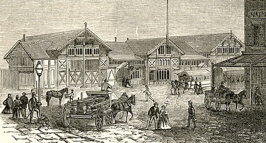
Brooklyn was perfectly situated to take advantage of Manhattan’s dearth of space and create a convenient shipping and storage port that was no longer possible in New York City. In 1841, Daniel Richards began construction on what would become the largest shipping and storage facility on the continent: The Atlantic Basin. However, in order to allow larger vessels to enter the basin at all tides, it was constructed far out into Buttermilk Channel, just beyond the marshes and islands of Red Hook. It actually took an act of the State Legislature to “officially” extend the coastline by several hundred feet so that he could do this. For many years, the construction site became an island at high tide and was accessible only by boat. This meant it would take a lot of grading in order to (a) complete the Basin, and (b) connect it to the mainland.
If you have ever heard the name James S.T. Stranahan, it was likely in association with the construction of Prospect Park, for which he was instrumental in bringing about. His statue can still be found there, just inside the gates facing Grand Army Plaza. However, 20 years before Prospect Park opened, Stranahan was the primary shareholder of the Atlantic Dock Company and a major property owner in Brooklyn. In 1846 Stranahan owned a good portion of what would ultimately become known as Carroll Gardens, including a large mount of earth known as Bergen Hill.
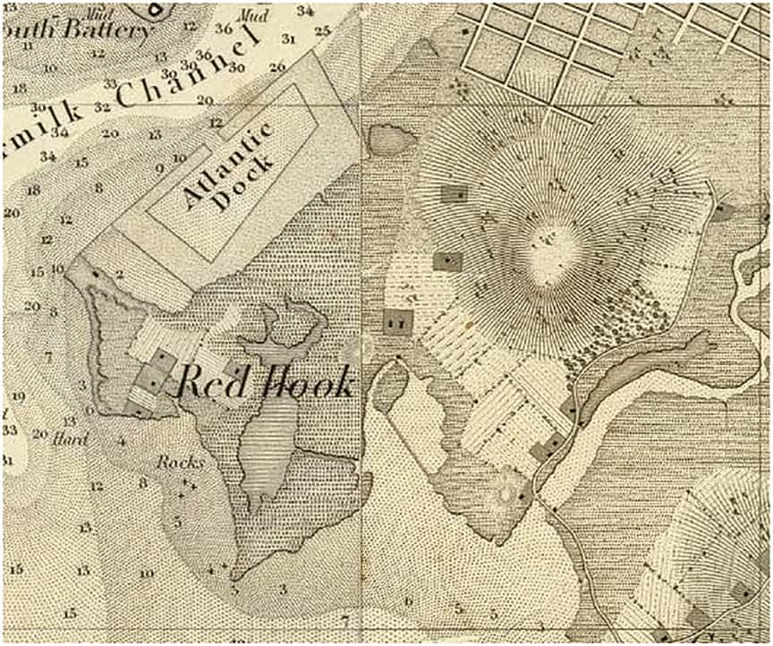
The chart to the left shows the Red Hook and Carroll Gardens sections of Brooklyn as they appeared in 1844, before the Basin was even completed. You can see the area between the Basin and Red Hook Point was still water with a depth of 2 feet, and the stippled cross-hatching all around the Basin indicates the area was dominated by marshes, subject to tidal flooding. Bergen Hill is to the Basin’s east: the light round spot with lines sweeping away from it. The hill peaked at the present location of Court Street and 2nd Place but was 60 feet taller than its present elevation, and probably had a much steeper grade.
Connecting Atlantic Basin to the mainland using Bergen Hill
Not long after taking charge of the project, Stranahan did what any person who owned property that needed to be raised in order to be developed right next to property that needed to be, well, razed in order to be developed would do: he used the one to fill in the other. In 1846, Stranahan hired laborers to begin cutting away at Bergen Hill in order to fill in the marshes and connect Red Hook to the rest of Brooklyn.
Using pickaxe, shovel, and dynamite, the mostly Irish workforce would load cart after cart, and wheel them down to the shore line. It was in this way that all the land west of Hicks Street from Kane Street down to about Hamilton Avenue where it met the Basin was created. The work was very dangerous and oversight was often minimal. Between 1846 and 1853, the Brooklyn Daily Eagle printed frequent articles about injuries and deaths resulting from walls of earth breaking away from the hill and crushing the laborers below.
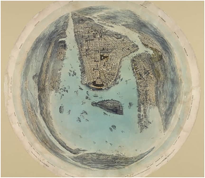
By 1853, the Atlantic Basin and what was then known as Red Hook were connected to the mainland. However, practically everything east of Richards Street was still under water and would remain so for a long time to come. In the 1859 print by John Bachmann depicting “New York City and Environs” at a bird’s-eye view through a kind of fish-eye lens, we see Brooklyn on the right hand side of the print. Sure enough, the Atlantic Basin is connected to the mainland. However, it seems to hang off of Brooklyn like an elephant’s trunk, dangling into Gowanus Bay. The rest of Red Hook as we know it today would be slowly filled in over the next 75 years.
So next time you take a stroll along the Columbia Street waterfront, use the bike path on Imlay Street, or bring the kids to play in Carroll Park (Court and President Streets), remember that technically, you’re on Bergen Hill. And I will continue my breathless runs up and down 3rd Street, thankful for the fact that it really is no hill for a climber, at least compared to what it once was.
Post script
The Atlantic Basin’s success was immediately evident and was to be seen for decades to come, remaining one of the busiest points of the Port of New York well into the 20th century. Much of this success is often attributed to the private investors and land-owners who took the risk of building not only the Basin but the very land around it. During these years of success, its soaring profits stood in contrast to those of Manhattan’s waterfront, where, under municipal ownership, the gears of government were slow to respond to the needs of enterprise.
During this period of economic and social development in Red Hook, the goals of these private investors were fairly well aligned with those of the public good – a vibrant commercial and industrial space providing thousands of jobs and enabling the growth of a thriving middle class economy. However, that does not always remain the case, and when a condo with waterfront views becomes more profitable than a warehouse with waterfront access, a little municipal oversight isn’t always a bad thing.
Author
Discover more from Red Hook Star-Revue
Subscribe to get the latest posts sent to your email.
5 Comments
Love the history of the old hook.
proud to be from there! Never heard the term “Bergen Hill”. Thanks !!
when I was a kid nobody wants to come to Red Hook always saying that it was dangerous not knowing what they were talking about,houses were reasonable rent for cheap and everybody was friendly now all newcomers have done nothing but push us out of the neighborhoodand they don’t want to be your friend they want to own the neighborhood what a sad ending to Red Hook
Lots of history in Red Hook…. who knew!!
Thanks for the ride back through History!